Ships Log
Cruise Reports of the S.C.G.S.C.
|
Ships Log Cruise Reports of the S.C.G.S.C. |
|
| Cruise to Isles of Scilly, 2008 | August, 2009 | |
|
Scilly Isles Cruise 2008
Explorers 2008 planned cruising programme kicked off with the now annual off-shore cruise. For this year the destination was the Isles of Scilly. The Isles of Scilly consist of an archipelago of approximately fifty islands located some thirty miles west of Lands End, the most south‐westerly point of England. The cruise was scheduled from 13th to 20th of June. However, as the 13th fell on a Friday some of the more superstitious crew members were unwilling to leave on that date. So, departure was settled for the following day. By the time the trip had come around the crew available had been reduced to four: Victor Shine (Skipper), Mick Collins, Eddie Mc Eoin and David Power. To ready Explorer for the trip a check‐list of tasks was drawn up at the pre cruise planning meeting held on the 9th. As the week proceeded a threat to the viability of the cruise emerged: not from any of your usual suspects such as bad weather or equipment failure but from a lightning strike carried out by fishermen on the 10th. The strike ensured that Cork harbour was closed by means of a blockade of trawlers circling at the harbours mouth. With uncertainty about the duration of this blockade, the thought of it lasting until the weekend and causing the cruise to be cancelled emerged as a distinct possibility. Anyway, it was full steam ahead with ticking off the items in the task list. 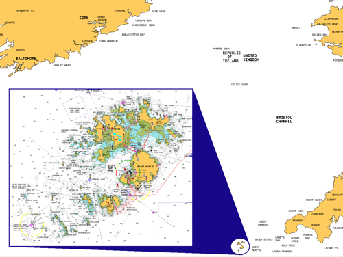 Figure 1: Location of Isles of Scilly relative to Irish South Coast and South West of England. Inset: Larger scale image of the Islands Watching the blockade from the shore, absolutely nothing passed it. The sight of roughly sixty trawlers stationed at the harbours mouth was still quiet impressive though. By noon the following morning the blockade had been lifted and the cruise was back on (although the possibility of a repeat before the weekend couldn’t be ruled out.) Anyway, it was full steam ahead with ticking off the items in the task list. Explorer was serviced, prepared and fuelled by the scheduled departure date of 14th June. The final sourcing of vittles took place on the Saturday morning when the crew all met outside Carrigaline Super Valu. One well stocked shopping trolley later we were off to the next stop: Lidl, Carrigaline, for the last few supplies. Then it was onto the boat to start stowing the vittles. With all supplies stowed by lunch time it was off to Cronins for the now apparently customary pre-departure lunch. 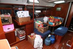 Figure 2: Some of the supplies prior to being stowed. Back to Explorer, we departed the marina at approximately 14:40 and were finally on our way. Our TR was issued to Cork Coast Guard Radio just as we passed the boatyard marina. Our course was set for 147oT from just south of Roches Pt. Maintaining an estimated SOG of 7 knots, our eta in St. Marys would be 12:40 the following day, approximately 22 hours. As we exited from Crosshaven we had to pick our way through the fleet participating in the 2008 classic boat regatta. This proved a bit difficult as the fleet was embroiled in thrilling, fast paced racing, as shown in the photo. 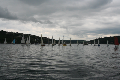 Figure 3: Picking our way through the 2008 Classic Boat Regatta field. On with the cruise, the weather was fair, with a nice breeze: possibly even a little too light for the two more experienced crew members. The engine was fired up to give that little bit extra drive to ensure the desired SOG was maintained. The weather was even fair enough to permit the deployment of the spinnaker. By 19:00 we were just about 3 miles east of the gas field and tucking into our evening meal. Our chosen watch system of 2 hours on 2 hours off was put into effect at 20:00, with Victor and Eddie taking first watch. The spinnaker was taken down at the 22:00 watch change, just around sunset. 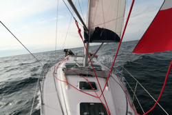 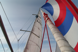 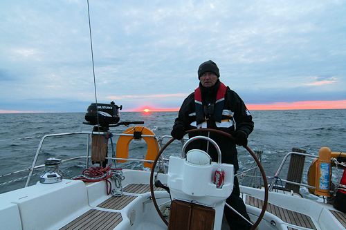 Figures 4, 5 & 6: Sailing under spinnaker, Eddie at the helm just before sunset. Now for the science bit: For this cruise Dave had brought along his electronic navigation system. This consisted of a number of devices including Laptop, Navigation Software with appropriate charts and also an Automatic Information System (A.I.S.) Receiver. The SOLAS regulations require all ships of 300 Tonnes or more to continually broadcast certain information over VHF. This information includes: Name, MMSI, Speed, Heading, Call Sign, Length, Beam, Draught, Destination and some more. Information is broadcast every couple of seconds by means of a special transponder and any vessel equipped with a suitable receiver can pick it up. The navigation software can use this information to plot the vessel, its course, its track and list the information described above. When large ships are within VHF range their course, speed and whether or not they pose a threat can be quickly assessed. For example, consider the photo below: Three vessels can be identified: Explorer, indicated by the cursor within the yellow circle, the supply ship for the gas rigs (inside blue circle) and the Pont Aven car ferry (Red Circle). The benefits of this system can be seen at night time. For example, during the 02:00 – 04:00 watch on the morning of the 15th, a couple of lights were spotted off in the distance. Immediately a number of questions arise: what is it? How far away is it? What direction is it travelling? One look at the AIS screen revealed all: The vessel was one of Arklow Shipping’s ships, destination was Foynes, it was approx 5nm away from us and travelling westwards at 15 knots. The range was confirmed by radar target. While it proved successful in this trip there are a number of caveats to its use: not all vessels are required to broadcast AIS information. For example trawlers and naval vessels are exempt, although they may broadcast information voluntarily. So as the saying goes, it’s an aid to navigation but no substitute for proper seamanship. 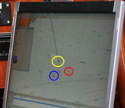 Figure 7: Laptop screenshot showing AIS contacts Now back to the cruise bit. By 10:00 on the morning of the 15th we were within visual range of the islands. The sea was literally flat calm as can be seen from the photo below. Even at this time we were still about an hour from St. Marys. A haze made it difficult to pick up on the various buoys and marks until we were practically on top of them. Finally, we were all secured to one of the visitor moorings by 11:00. Due to a strike by HM Coastguard, no TR was issued as they were not accepting routine traffic. They were only responding to emergency calls. The outward trip took in total 21 hours, we covered 140nm giving an average SOG of 6.75 knots. Once the boat was secure, the dinghy was inflated and Victor dispatched to announce our arrival to the local harbour masters office. Once we had tidied up a bit we took a couple hours of R&R. The rest of the day was spent wondering around St. Marys. After the dull start to the day the sun eventually broke through to give one of the best days of the summer, positively Mediterranean like.  Figure 8: Flat calm approaches to St. Marys Over the course of the rest of the week breakfast typically turned into brunch. A breakfast routine was quickly established from day 2. Production of such a mouth watering menu normally took two hours. The Breakfast menu typically consisted of 1 bowl of cereal of your choice as long as it was Kelloggs cornflakes, one glass of juice (orange, apple, cranberry), 1 full Irish consisting of at least 2 sausages, 2 eggs, 2 bacon, 2 pudding, one black, one white, beans and fried potato all washed down with tea or coffee. It was observed that the scent of this feast wafting across the visitors moorings was the cause of some salivating by some other crews. In one case we were even the subject of some photographs...all very entertaining indeed. By the time breakfast was finished, we were set for the day. If the old saying of armies marching on their stomachs is true, we could have marched for days! 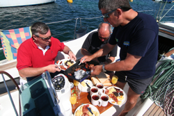 Fgure 9: Just your typical breakfast on board Explorer 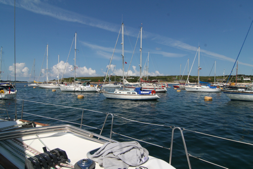 Figure 10: Mediterranean like weather conditions at anchor in St. Marys The second day dawned fine and sunny. Over breakfast we discussed what this days sail would consist of. We decided to head for New Grimsby Sound, an anchorage between the islands of Tresco and Bryher. However, we decided to go via Saint Marys Sound, south west towards the Bishop Rock light house and back north to our destination. The Bishop Rock stands guard to the south west of England, just like the Fastnet stands guard to the south west of Ireland. We slipped the visitors mooring at 12:42 pm amidst a blaze of sunshine. Two hours later we had passed the Bishop Rock and were sailing a northerly heading en route to New Grimsby Sound and our anchorage for the night. We entered New Grimsby sound at approximately 16:15 and were securely attached to one of the visitors moorings 15 minutes later. That evening we went for a walk (hike?) around the northern half of Tresco before returning to Explorer to prepare the evening meal, and retire for that night. During the night there was a distinct change in the weather with a nice swell building from the North. It was quiet an uncomfortable night, interspersed with several trips up on deck to check things out. 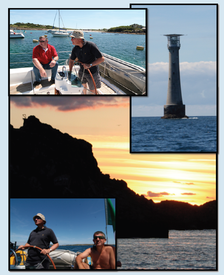 Figures 11, 12, 13 & 14: From top left, Steady as she goes Eddie, Eddie at the helm leaving St. Marys, The Bishop Rock Lighthouse, Hangmans Island at dusk in New Grimsby Sound and Eddie again at the helm south of the Scillies. The following day saw us explore the southern half of Tresco. This also included a visit to the Tresco Abbey Gardens. The gardens, covering an area of 17 acres, were started in 1834. They contain plants from many different parts of the world. Typically such plants would not survive on the mainland, however, the Gulf Stream allows the plants to survive in this location. Whilst exploring the gardens we discovered a unique and interesting feature called the Buda Shine Shrine!, Figure 15. Legend has it that if you make a suitable contribution to the shrine the buda will dispense some words of wisdom. We were not able to put this rumor to the test as we were unable to raise a contribution of significant value. It would have been nice to hear from the buda...maybe next time. 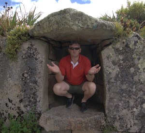 Figure 15: The Buda Shine Shrine Another interesting part of the gardens is the Valhalla Ship’s Figurehead Collection. This is a collection of figureheads from old ships that perished on the islands. When finished examining the flora and fauna of the bottanical gardens it was time to make our way back to our accomodation. 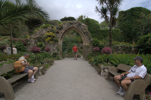 Figure 16: Taking a break amongst some of the ruins in the gardens With the swell that had built up the previous night, and a poor forecast for the next day or two we decided to slip our moorings an return to St. Marys. We departed our mooring at 16:45. The wind was quiet strong, with a moderate swell that had built up since the previous night. At times we were averaging between 8 to 9 knots, at one stage reaching a maximum of 13.7 knots. Traveling at these speeds we covered the 10 nautical miles in approximately 90 minutes. We were secured to one of the visitor moorings in St. Marys by 18:15, this time though there was a little more effort expended in picking up the mooring. Dave manned the boat hook to pick up the chain while Mick attached the morring line. Even with the wind contitions freshening Dave managed to hold on until Mick securely attached the line. Our efforts were the source of much amusement for some other boats nearby. We even got a bit of an ovation when we had secured the line. We suspect it may have been due more to boredom from the observers part rather than the chance of an impending catastrophe on our part. 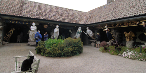 Figure 17: The figurehead Collection at Valhalla. We again deployed the dinghy to take us ashore. The outboard was a bit sick for the week due to a worn bushing resulting in some prop slippage. Anyway, when Dave and Mick were heading back to Explorer there were a few french sailors in a small dinghy that couldn’t get their outboard started. Mick offered to tow them to their craft, they gladly accepted. However, to our surprise there was two dinghys worth of them (8 people in total). One of them came along with us to give directions, but his English was about as good as our French (hopeless). The sight of one barely running dinghy towing two non running dinghys out St. Marys harbour in pretty rough conditions must have been amusing to the spectators that had gathered along the quay. Thank god there are no photos! Language barriers aside, we managed to identify their yacht. We took a broad sweeping turn around the trot, lined up to pass close to their yacht and directed our passenger to jump. There was to be no stop on our part for fear of loosing whatever drive we had left in our outboard. We have to admit that we weren’t sorry rid of them. At one stage during the tow we considred casting them adrift in the middle of St. Marys harbour. This was going to be our fall back plan if things started to go wrong. The conditions at the time would have blown them back onto the quay, so there was no major danger. 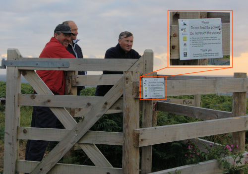 Figure 18: Warning to visitors to not feed or touch the ponies. The lack of food or contact didn’t seem to affect these ponies! After dinner we went for another walk around St. Marys, the Star Castle Hotel and along the western cliffs. In our travels along this route we found a number of interesting features including some cannons that formed part of the islands past defences. One of our crew members was admiring such fine examples of traditional weaponary. After some debate it was decided that we would not be able to bring it the cannon home with us. What a shame. During this excursion we also discovered the local soccer pitch on St. Marys island. For those of you that have no interest in soccer, skip to the next paragraph, otherwise read on. The Isles of Scilly are home to the worlds smallest official soccer league. The league consists of just two teams: The Garrison Gunners and the Woolpack Wanderers. The two teams play each other a number of times each year in both league and cup competitions. 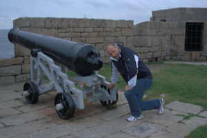 Figure 19: Well skipper, can we bring it back with us? After our trek around the coatline we found ourselves back at the Star Castel hotel, time for much needed libations. Libations consumed, it was time to return to explorer for the night. The final day of the cruise was spent checking out the various shops in St. Marys. Weather contitions were so poor that any sailing was ruled out. This was confirmed when a neighbouring French 50 footer crewed by three people decided to move moorings to be closer to some of his compatriots. Three times he was nearly blown on top of the lee shore. They made several attempts to pick up the mooring but just couldn’t hang onto it. Eventually the skipper reversed up to the mooring and picked it up from the stern. Using a combination of their friends dinghy, some long lines and fancy ropework they eventually managed to transfer the mooring to the bow of the yacht. We decided to have a meal ashore that night as it was the last night of the trip. The forecast for the following day was for it to be moderating. So it looked like our departure window was arriving. We deprted for our return trip at 12:33 on the 19th June. For the first half of the trip we were averaging around 8 knots SOG. However during the night spped dropped back to about 6 knots. We then used the engine to maintain our targert og 7 knots SOG. Explorer was finally secured at her berth by 08:50 on the morning of June 20th. Another item of possible interest to members of the club is rumours about a possible upgrade to Explorer. The Isles of Scilly form a stopover for many cruises beteen Ireland, England, France and further afield. As such, you get the opportunity to check out many different types of yacht. This was certainly true this trip. One vessel particularily took the fancy of our skipper and first mate: 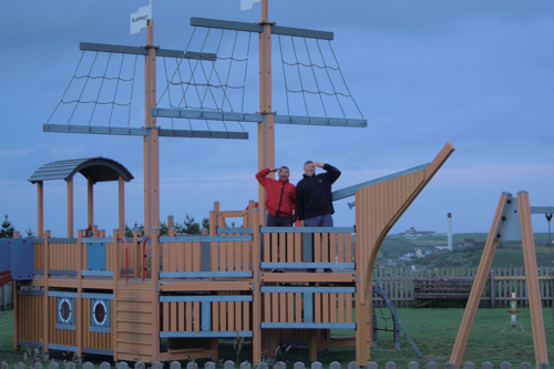 Figure 20: Explorers replacement? The table below gives a brief log of the trip, with an image of the trip shown afterwards. The blue lines in the image indicate the track covered during the trips detailed below. 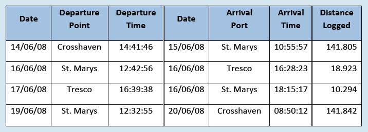 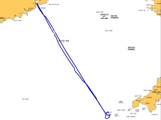 Figure 21: Track covered during Summer Cruise 2008. Finally, coastal and offshore cruises for 2009 are currently being planned. They are a great way to build skill levels of sailing, navigation, milage etc. Most of all they can lead to great adventures and stories that may become legend, (See 2007 cruise report). Remember, experience is not necessary, so give it a go! Report by David Power. |